Are you passionate about conservation programs that provide measurable benefits to nature and people? Do you want to join an exciting team of collaborators through the PAD III work? We have two PhD projects that will work closely together and with ICEM and other partners in Cambodia to contribute to on ground conservation programs. We encourage potential applicants to reach out directly to myself via email (vm.adams@utas.edu.au) early to discuss PhD entry requirements and processes and to then work with our full team to develop project ideas as part of the application process.
Are you headed to ICCB 2025 in Meeanjin Brisbane and attending our Student – ECR Day? I’m really pleased to be helping host the Student – ECR day June 15th so if you’re registered to join us for the day see you there! To get you excited here’s a bit more about what to expect in one of the 4 workshops – how to be a good mentor mentee.
We’ll share some resources as well for anyone not able to join so watch this space.
The SCBO hosted Student – ECR Day at the International Congress for Conservation Biology 2025 has received funding support from the Australian Academy of Science’s Theo Murphy Initiative (Australia) program and the University of Tasmania.
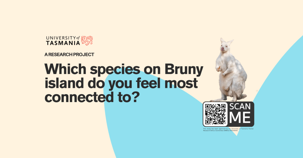
Edith Shum, a PhD student at UTAS, is leading research on the role species play in shaping connections to Bruny Island. You may even have heard her on ABC Hobart radio talking about the project or seen the project page on Facebook https://www.facebook.com/profile.php?id=61556398648068
Does that sound like you – if so participate in the survey.
Completing this brief survey will require just 10-15 minutes of your time. As a token of appreciation, you’ll have the opportunity to enter a draw for a chance to win a $𝟭𝟬𝟬 digital gift voucher to indulge in treats from the renowned Bruny Island Cheese Co.
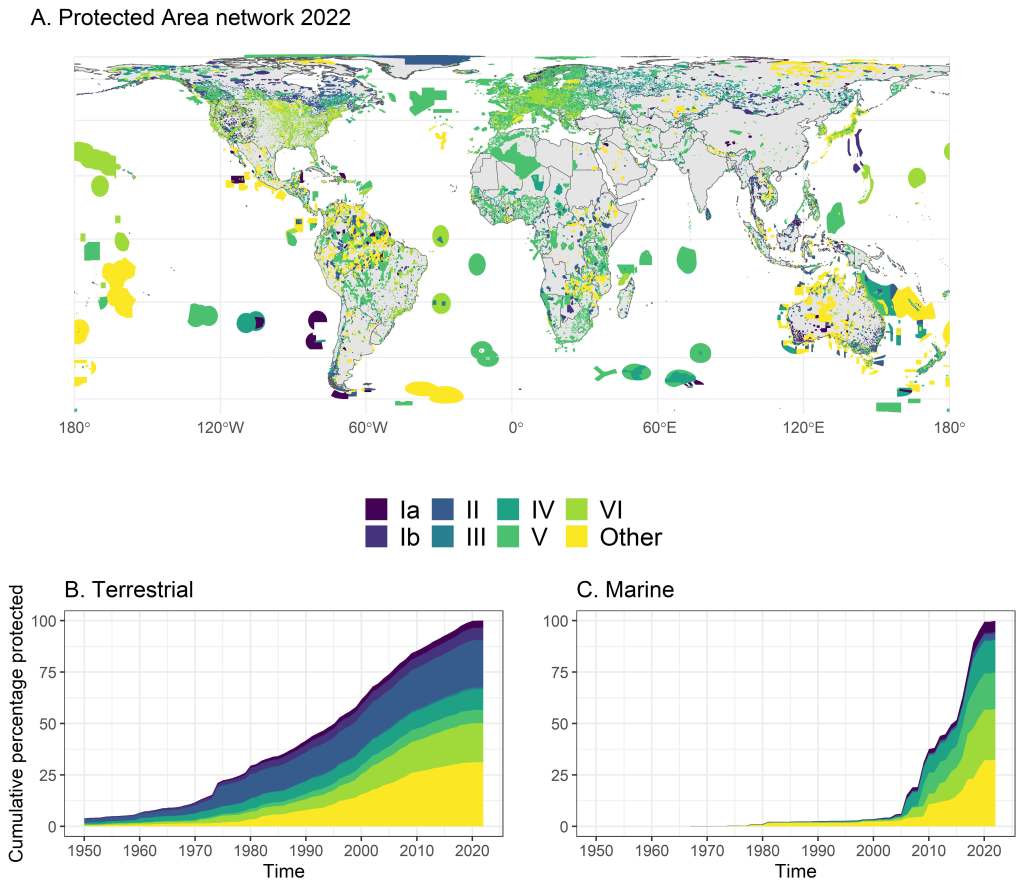
If you want free access (for next 90 days) to our One Earth Review “Multiple-use protected areas are critical to equitable and effective conservation” please follow this link and download now: https://authors.elsevier.com/a/1hm7A9C%7EIu09pz.
If you miss out on the 90 day window just email me at vm.adams@utas.edu.au for a PDF too.
A bit about how we came to the conclusion that multiple-use protected areas are critical. We (myself, Alienor Chauvenet, Caitie Kuempel, Natasha Stoudmann, Georgina Gurney, and Dan Brockington) set out on a journey to review and synthesize evidence to date on the growth of the protected and conserved estate, where and why it was working, and where and why it wasn’t working and creating harm (to nature and people). In doing so we gathered a range of data and sources and independently began to re-analyze them. We didn’t set out to study multiple-use protected areas specifically, but what we found in the data through our various analyses is that they were profoundly important in terms of total area protected, proportion of global estate, alignment to equitable and effective conservation goals, and documented evidence that they can be effective in protecting biodiversity (and sometimes even more so than their strict counterparts). Essential to our approach was having a research team with diverse disciplinary backgrounds and personal value orientations to conservation, but that were open to what the data and results. We applied evidence based approaches alongside robust discussion and the outcome was our perhaps unexpected and not originally intended conclusion that multiple use protected areas are critical to equitable and effective conservation. The process of analyzing the global data and synthesizing the evidence to inform the future growth of the global protected and conserved estate was a particularly rewarding if not challenging experience — there’s a lot of data and analyses in there so it was not simple task to bring it all together but the team was up to the task!
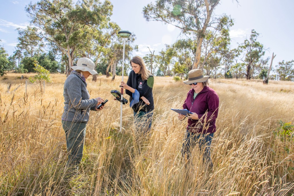
This year I spent International Women’s day out in the field with students and some amazing (female) colleagues. I sadly missed the annual Tasmanian Land Conservancy Women in Conservation event – but instead got to do some live women in conservation activities like field surveys for caged and un-caged Eucalyptus saplings to determine if caging is a successful strategy to protect saplings from deer damage and wallaby browsing. Is there any better way to celebrate great conservation science and International Women’s day than in nature?
Photo credit Peter Allen University of Tasmania: Women in Conservation – Kerry Bridle, Vanessa Adams, and Karen Johnson surveying Eucalyptus seedlings and saplings on a conservation property in the Midlands.